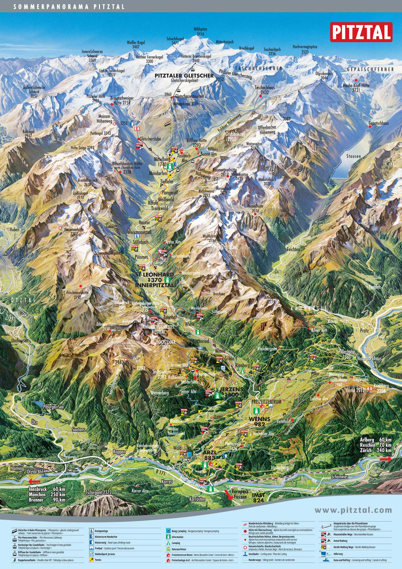
Pitztal Hiking
![]()
Hiking Arzl
Arzl - Hohe Bank
time: ± 1 hours
easy route
From Arzl past the sports fields, and over the hill from the Osterstein.
Luis Trenker Steig
time: ± 45 minuts
easy route
This famous climb goes from the Walder Brücke through the Pitzenklamm to the railwaybridge over the Inn.
Benni Raich Brug
time: ± 3 hours
medium route
From Arzl in direction of Pitzebene, where you'll find a magnificent view at the suspension bridge with a span of nearly 138 meter. After admiring the bridge, cross the bridge to the Weiler Wald.
Wald - Bichl
time: ± 1,5 hours
easy route
From the parking lot at Waldeck in the direction Krabichler. At the 2nd farm, go to the left to Waldboden. Then to the mountain station of the Galtwiesenlift and along the Wennerbergweg back to the starting point.
Arzl - Gasthof Plattenrain
time: ± 2 hours
medium route
From the church along the Serpentinenweg in the direction Burgstall, Weiler Arzlair and Alpengasthof Plattenrain.
Arzl - Imsterberg - Arzl
time: ± 3 - 4 hours
medium route
From Hotel Post in the direction of the wood works. Along the broad Forstweg and a small climb to Imsterberg. Back through Imsterau, the powerplant and the industrial area to the center of Arzl.
Wald - Waldeck - Wald
time: ± 2 hours
medium route
From the church square in Wald to the sawmill. After about 300 meters turn right. Along the Salmersteig through the forest, and along the normal street back to the starting point.
Oberleins - Kirchplatz
time: ± 3 hours
medium route
From the center of Leins along the bus stop in the direction Oberleins. Then the direction Krabichl. Through the Forstweg to the right untill the big pasture (approximately 1.5 hours), and then at the intersection to the Leiner Alm. Descend to the Leiner Mühle and through Gabne back to the starting point.
Hiking Jerzens
Jerzens - Stuibenwaterval - Jerzens
time: ± 2 hours
easy route
300 meter after the nameplate at the entrance of the village (on the leftside) the route begins to the waterfall. Back through Schön to Jerzens.
Falsterwies - Gischlewies
time: ± 1,5 hours
easy route
The walk starts just above the center, and goes towards Weiler Falsterwies and Weiler Gischlewies.
Egg - Innerwald - Jerzner Alm
time: ± 3 hours
At the firedepartment over a small climb to Weiler Egg. Through the Forstweg to the Jerzner Alm.
Hochzeiger - Kalbenalm - Jerzner Alm
time: ± 1 hours en 15 minuts
easy route
From the mittel station of the Hochzeiger to the Kalbenalm and the Jerzner Alm.
Hiking St Leonhard im Pitztal
St Leonhard im Pitztal - Mittelberg
time: ± 3 hours
easy route
From St Leonhard im Pitztal, through Bach, Trenkwald, Köfels, Weißwald, Plegeross, Tieflehn to the Taschach Alm. Left and across the stream in the direction of Mittelberg.
Fuldauer Höhenweg
time: ± 7 hours
medium route
With the Rifflseebahn to Rifflsee. Left along the lake, across the creek to the intersection Fuldauer Höhenweg. Follow the climb (moderate) to the Vorderen Köpfl. Climb over some rocks. Descend to Kar and the Taschachhaus. Back on the road to the Taschachalm and Mandarfen.
Pitztaler Almenweg
time: ± 8 hours
medium route
Approximately 100 meter before the start of Wiese right to the Söllbergalm. From here in the direction of Brechsee. After ± 30 minutes turn in the direction Stallkogel and Mauchele Alm. From the Mauchele Alm in a moderate climb, and after ± 500 meter (at the red mark) left to the stream. Turn left towards Neubergalm. Then direction Tiefentalalm, and the footpath to the road to the Arzler Alm. Follow this road downwards.
Ludwigsburger Hütte (1.935 m)
time: ± 4 hours
easy route
From the parking lot Zaunhof / Grübl, along the well-marked (sometimes steep) climb or the road to the Ludwigsburger Hütte.
Around the Rappenkopf
time: ± 5 hours
medium route
From Piösmes to the Arzler Alm. From here to the top of the Rappenkopf.
Hiking Wenns
Matzlewald Kieleberg Alm
time: ± 3 hours
easy route
At the sawmill right in the direction Kielberg Alm. After about 15 minutes left towards Stein and Kielberg Alm. Along the road back to Matzlewald.
Matzlewald - Klausboden
time: ± 1 hour en 45 minuts
easy route
In the direction Klausboden, and at the sawmill in the direction Wenns (cross the bridge and along the stream). From Klausboden back to Matzlewald.
Wenns - Pitzenhöfe - Wiesle
time: ± 3 hours
easy route
From Gasthof Pitztaler Hof in the direction Wenns. At Brennwald through the Pitzenhöfe, across the Pitze and in the direction center of Wenns.
Taschen
time: ± 5,5 hours
medium route
From Taschen along the Forstweg to the Gaflun Alm (follow the signs). By the road to the Larcher Alm and then downwards to the Gstoanigkapelle. Further on the footpath across the Salzmöser, and back to Taschen.
Audershof - Gstoanigkapelle
time: ± 1,5 hours
easy route
Follow from Audershof the signs to the chapel.
Audershof - Larcher Alm
time: ± 3 hours
easy route
From Weiler Audershof along the Forstweg to the Larcher Alm.