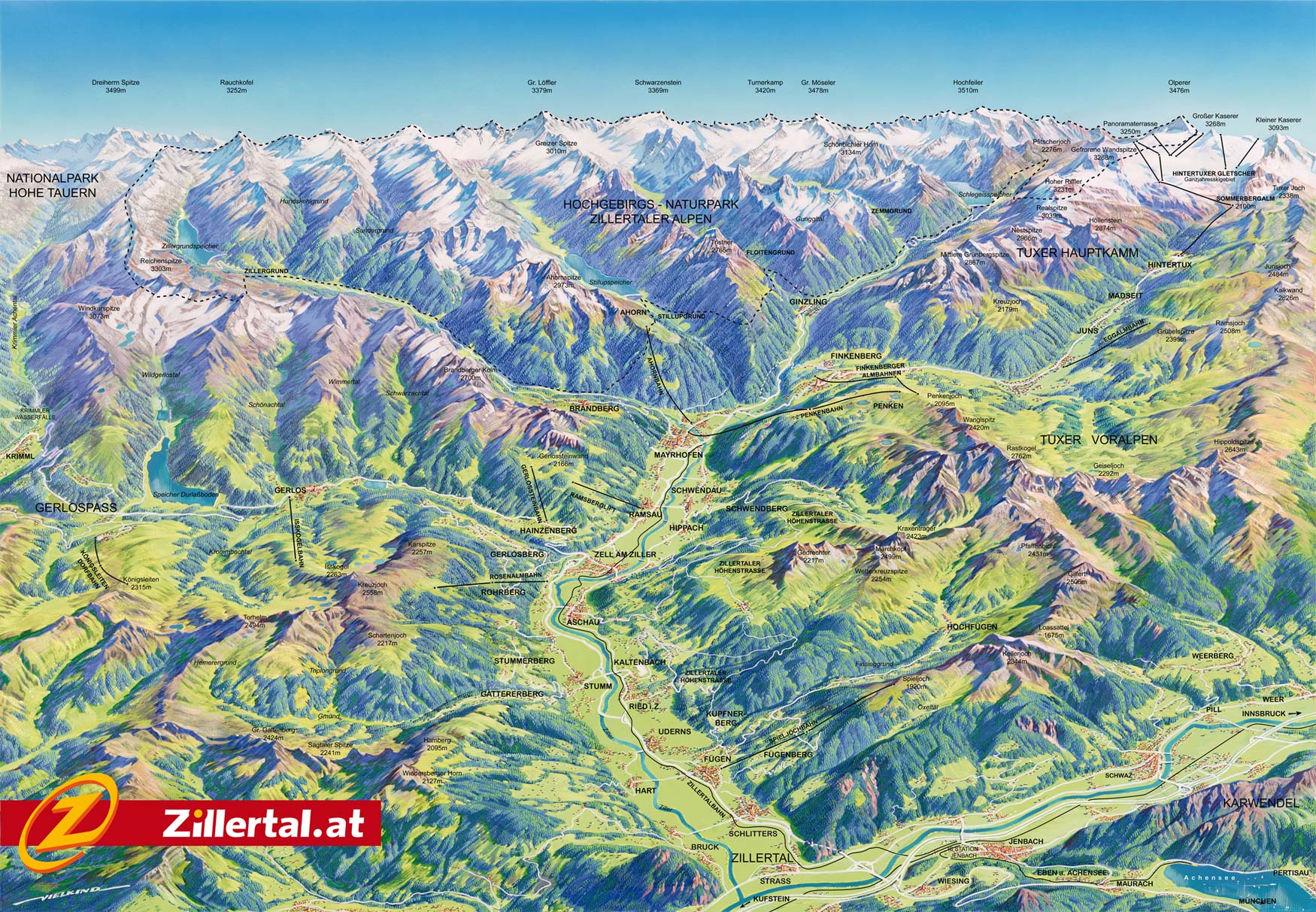
Fügen Hiking
![]()
Hiking Routes
Fügen - Uderns - Fügen Nr.1a
time: ± 1 hour
easy route
From the Tourist Information Office, along the sports fields direction Hart. Across the Ziller Bridge right. Along the Ziller and at the Schäffstallbrug right direction Gasthof Giessenbach, along the Bundesstraße to Kapfing, or before the Gießenbachbrug right to Gasthof Schöne Aussicht. From here along the Bundesstraße to Fügen.
St. Pankrazkirche - Jausenstationen Oberhaus - Seehüter Nr. 1
time: ± 3,5 hours
medium route
From the Tourist Information Office, across the village square, along the Pfarrhaus and Hauptschule until the bypass. Further direction Spieljochbahn. At apartment house Spieljoch left to the St Pankrazkirche. From here towards Gasthof Steiner. Shortly before the Gasthof right direction Kupfnerberg. ± In 30 minutes you reach Jausenstations Oberhaus and Seehüter. Back on the Krapfenboden. From Jausenstation Seehüter a little bit up, left to the Platzlstall. Again left to Uderns. Along the Edhof, and through Kapfing back to Fügen.
Marienberg Kirche – Spieljochbahn Nr. 2
time: ± 1 hour
easy route
From the Tourist Information Office, along the village square and at the stop sign (Hotel Post) right on the Hochfügener Straße until the intersection direction Marie Berg, turn right and follow signs to the church. From here the path goes through the forest to Hotel Bruno. Follow the road 200 meter and at the barn right until Hotel Waldfriede. From here along the Spieljochbahn and back to Fügen.
Kirche Oberhart Nr. 3
time: ± 2 hours en 45 minutes
easy route
From the Tourist Information Office, across the square towards Hart, across the bridge to Oberhart and the church.
Schlitters Nr. 4
time: ± 3 hours
medium route
From the Tourist Information Office, direction Fügen-north, and along the new roadway (street) parallel to the Bundesstraße. Alon camp site Zillertal along the old road to Schlitters. In the center at Raiffeisenwarenverband right and under the road across the railway to Imming. Right direction Hart. Along the Ziller to the Gasthof Neuhäusl. From here to the bridge and right again, past the sports fields to Fügen.
Goglhof – Kohleralmhof Nr. 5
time: ± 3 hours en 15 minutes
From the Tourist Information Office to the Marienberg Church, then left along the Graf-Fieger-Way until a small bridge. From here follow the signs Goglhof. From the Goglhof the road goes to the highest farm Kühstein. Further to the exit Mittelstation Spieljochbahn and Kohleralmhof.
Gasthof Sonnberg – Kohleralmhof
time: ± 1,5 hours
easy route
From the valley station Spieljochbahn, on the asphalt road towards Hotel Waldfriede. Just before the hotel the hiking route bends left uphill to Gasthof Sonnberg. After the Gasthof a short piece on an asphalt road and then through meadows and forests direction Mittelstation. At the farm Obergäns along the ordinary road towards Mittelstation.
Fügen – Geolsalm Nr. 6a
time: ± 1,5 hours
easy route
From Mittelstation Spieljochbahn direction Geolsalm. From the alm to the mountain station Spieljochbahn.
Gasthof Brandegg en Gasthof Baumannwies Nr. 6
time: ± 2 hours
medium route
From the Tourist Information Office on the Rosenweges until exit Putzatal. Turn left and uphill and follow the footpath until it turns into the street. A short piece on the street to the junction. From here continue on the street to Gruaben. Until Gasthof Brandegg through meadows. From here follow the road to Gasthof Baumann Wies. Further to the mountain station Spieljoch or Geols- and Gartalm is possible.
Spieljoch - Fügen Nr. 7
time: ± 3 hours
medium route
From the mountain station Spieljochbahn Downwards to the lake Arzjoch. Direction skihut, along the skihut, through the forest and continue to the Mittelstation and Gasthof Kohleralmhof. From here on the asphalt street. Before the farm Obergäns right on the hiking route through the woods (along Gasthof Sonnberg) to Fugen.
Rondwandeling Spieljoch - Kellerjoch (AV 312). Nr. 8
time: ± 5 hours
medium route
From the mountain station Spieljochbahn direction Geolsalm and then towards Hochleger (1830 m). From here follow the markings on rocks and stones to the Keller Joch-Hütte. Same way back.
Bergstation Spieljoch – Schaubergwerk Nr. 8a
time: ± 45 minutes
medium route
Follow the new Knappensteig.
Bergstation Spieljochbahn – Hochfügen Nr. 10
time: ± 3,5 hours
medium route
From the mountain station Spieljochbahn to the Spieljoch and on to the Geolalm and Gartalm. From here to the Gamssteinhaus. Then to the Maschentalalm, Lamarkalm and back to Hochfügen.
Bergstation Spieljochbahn - Schellenberg – Hochfügen Nr. 11
time: ± 3,5 hours
medium route
From the mountain station Spieljochbahn downwards, and ± 200 meter below the mountain station direction Geolalm. From here along Gartalm-Niederleger to the Schellenbergalm (Jausenstation Schellenberg). From here a short piece on the asphalt road towards Hochfügen. After ± 300 meter the road bends to the left in the Finsinggrund. About the Kegelalm or along the Finsingbach to Hochfügen.


